

10 Places To Hike In Colorado For Beginners
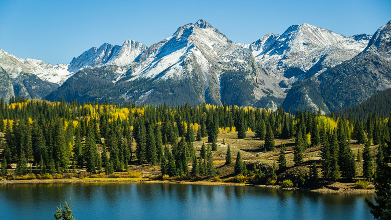
When it comes to hiking excursions, there are few places in the United States more dynamic than Colorado. While the Rocky Mountains offer up plenty of rugged routes demanding experience and serious preparation, you don't need to conquer a 14,000-foot peak to experience what makes Colorado hiking so breathtaking. In fact, some of the region's most memorable scenery is accessible on trails that are short, relatively gentle, and well-suited for someone taking their first steps into the great outdoors — perfect for first-time hikers.
When visiting Colorado, you'll find beginner-friendly paths winding around mountain lakes, pine forests, and enormous red rock formations, along with trails showcasing waterfalls, wildflowers, and local wildlife. Of course, "beginner-friendly" doesn't necessarily mean a flat walk through a paved park. These trails deliver excellent scenery to those who don't mind putting in a certain amount of work, and you'll still need to come prepared with proper hiking essentials like trail-rated footwear, water bottles, and high-energy trail snacks.
There are other factors to take into account as well: Colorado is high above sea level, meaning many trails begin at elevations that might be difficult for visitors to adapt to. That, plus the always-changing mountain weather, means you'll want to plan your adventure carefully, and bookend your visit with a bit of wiggle room to acclimate or dodge rain and snow. With any luck, you'll be ready to tackle some of these trails like a seasoned pro, even if you're new to hiking.
Bear Lake Loop
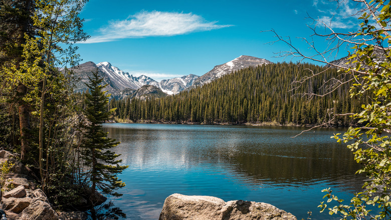
If you're looking for a beginner-friendly hike in Colorado, Bear Lake Loop in Rocky Mountain National Park is an appealing place to begin. The trail circles Bear Lake for just over half a mile, with roughly 71 feet of elevation gain, making it a quick outing, especially given the impressive views of the surrounding peaks. The trail begins at the Bear Lake Trailhead at the end of Bear Lake Road.
It's worth pointing out that Bear Lake Loop can be slightly difficult to pull up online, as search engines often confuse the trail with the Bear Lake Road Corridor. The latter is a roughly 10-mile drive, encompassing destinations like Moraine Park, Sprague Lake, Glacier Gorge, and Bear Lake. But sites like AllTrails and Trip Advisor have dedicated pages to the loop. Many reviewers specifically note the trail's accessibility, with one reviewer on Trip Advisor noting, "this hike is extremely easy for any beginner hiker." But the lake's beauty draws even experienced sojourners for its views and fall leaves. Those ready for a longer adventure will find plenty of other, more challenging trails intersecting this one.
Although the loop is short, beginners should note that the trailhead starts at an altitude of nearly 9,500 feet above sea level. Visitors accustomed to hiking at lower elevations may experience difficulty adjusting, if they haven't acclimated. Depending on when you visit, you'll also need a timed-entry reservation, and a pair of reliable waterproof boots. The trail is likely to be blanketed in snow from October through May or June, so be sure to pack for a winter hike. Parking is an issue during peak season, but there is a free shuttle from Estes Park and other locations, via Rocky Mountain National Park.
Coyote Song Trail Loop
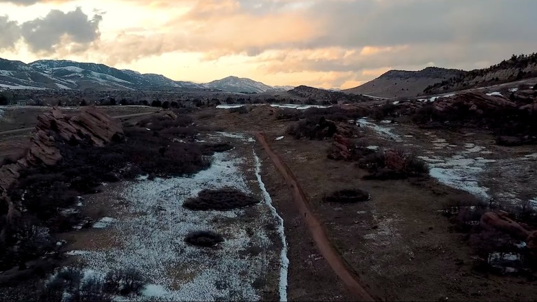
For a relatively simple, family-friendly hike close to the Denver area, it's a quick trip to experience the gorgeous scenery of the Coyote Song Trail Loop, outside Littleton. This loop, which can be found in South Valley Park roughly 40 minutes from the Mile-High City, gives beginners an introduction to Colorado hiking with a 2.9-mile walk through open meadows and striking red-rock formations. The loop is widely considered to be one of the best for new hikers, even with about 300 feet of elevation gain.
The 1-hour loop combines two shorter trails — Swallow and Coyote Song, providing excellent views of Colorado's Front Range, along with some unusual sandstone formations. The exposed rock formations along the trail give it a distinctly Colorado vibe without requiring hikers to venture deep into a national park. Interpretive signs along portions of the route provide information about the area's geology and history, giving beginners something to check out beyond the picturesque scenery. In the spring, the area is rich with wildflowers. You can also access somewhat more difficult trails like Lyon's Back, from this loop.
There is one major caveat associated with this hike: It offers a distinct lack of shade, so a sunny summer afternoon can feel considerably hotter and more exposed than some of the trails on this list. Pack plenty of water, sun protection, and maybe a hat. Venturing out early in the day can also help. Of course, this area also receives plenty of snow in the winter as well.
Big Easy Trailhead to Tunnel 5
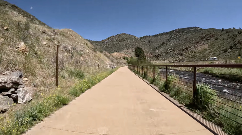
If you or someone you know has mobility issues, or you prefer cycling through a scenic path, the Big Easy Trailhead — part of the popular Peak to Plains Trail near Golden, Colorado — may be exactly what you're looking for. This relatively gentle, paved trail, is ten feet wide, ADA accessible, and perfect for probing into Jefferson County's historic Clear Creek Canyon. The trail follows Clear Creek, flanked by low, but dramatic hills, offering lots of opportunities to stop and take in the scenery. At the trailhead, you'll find plenty of parking, along with picnic kiosks and restrooms.
The Big Easy Trailhead is located at 32088 U.S. Highway 6, west of Golden, and provides access to the larger Clear Creek Trail, which continues through the canyon and connects with other trailheads, so hikers can choose how far they want to go. The canyon's rocky walls evoke the rugged landscape many visitors associate with Colorado, and the bridges and overlooks along the trail give hikers plenty of different perspectives on the creek and surrounding canyon. The original Big Easy-to-Oxbow/Tunnel 5 section of the Clear Creek Trail covers nearly 4 miles and gains roughly 500 feet in elevation, although beginners can simply turn around before completing the entire stretch. It is a there-and-back trail (essentially, the accessible section dead ends at Tunnel 5), and not a loop.
Bear in mind that the Big Easy Trailhead is a multi-use trail. That means cyclists may need to pass, so you should avoid using noise cancelling headphones, and remain aware of your surroundings. The Jefferson County website also cautions visitors to be mindful when they get close to the creek itself, as fast-moving water can create hazards.
Fountain Creek nature trail
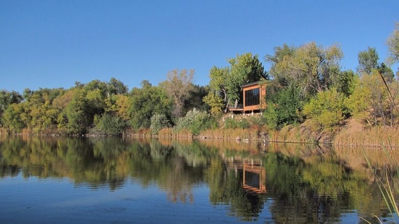
Colorado hiking doesn't always mean scaling heights to get a good look at the beauty of nature. The Fountain Creek Trail, located in Fountain Creek Regional Park, for instance, is a great place for beginners to explore Colorado's wetlands, meadows, and cottonwood woodlands. The loop, which intersects a larger regional trail, clocks in at just under a mile long, making it an especially approachable option for anyone who wants a short nature walk rather than a strenuous, uphill hike.
This trail begins near the Fountain Creek Nature Center, an environmental education facility operated by El Paso County. Rather than climbing into the foothills, the route stays close to the creek and winds around a pond and wetland habitat. That setting makes wildlife observation one of the biggest reasons to visit, with great blue herons and other waterfowl, turtles, deer, and other animals making frequent appearances.
Beginner hikers will note the relatively flat terrain, allowing you to concentrate on watching wildlife and snapping photos. The nature center also offers exhibits and educational programs, so the hike can easily become part of a longer visit. Be aware that neither pets nor bicycles are permitted on the trail, as part of a larger effort to preserve the wildlife habitat. Also, bring sun protection, as portions of the trail are unshaded.
Lily Lake Loop
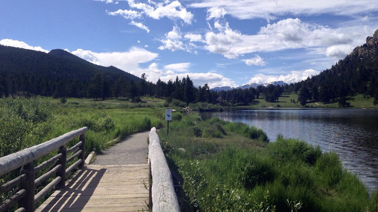
If you're seeking a Colorado hike that feels more like a scenic stroll than a mountain expedition, the Lily Lake Loop in Rocky Mountain National Park is a good place to start. This trail, running roughly 0.8 miles, circles Lily Lake just south of Estes Park (about 70 miles northwest of Denver). It follows a mostly level route through wetlands with views of the surrounding mountains. The National Park Service specifically recommends the area for wildlife and birdwatching, while benches and a viewing pier give hikers plenty of places to stop and enjoy the scenery. On clear days, visitors can see Longs Peak and other prominent sights reflected in the lake, while wildflowers add vibrant color to the surrounding landscape.
Like other hiking loops on this list, the terrain here is easily approachable. The trail is primarily made of compacted gravel and boardwalks, with very mild changes in elevation (10 feet) along the way. There are a few minor barriers, including small rises where the trail meets bridges, and the possibility of puddles after rain, but those are easily mitigated with the proper footwear.
Of course, like most Colorado hikes, this loop sits at a high elevation. At nearly 9,000 feet above sea level, visitors used to the coastal plains may find that Lily Lake takes their breath away in more ways than one. Though the trail itself is fairly accessible to wheelchairs, the loose gravel parking lot and adjoining trail can make getting there a challenge.
Paint Mines Interpretive Trail
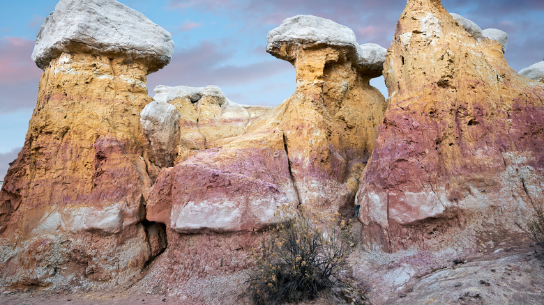
Taking things over to Colorado's eastern plains, we've got the Paint Mines Interpretive Park. This unique scenic experience, located just outside of Calhan, winds through grassland and into a maze of colorful clay formations, spires, and massive rock formations known as hoodoos. The Paint Mines Park has about 4 miles of trails in total, and the Interpretive Loop makes for a fun and easy introduction. Despite the name, the unusual colors along the hills aren't actually made of paint. Instead, these colors are the result of various clay formations, with bright bands created by oxidized iron compounds. Indigenous peoples as far back as 9,000 years ago hunted in these canyons, and collected the colorful clays.
With nearly 400 feet of elevation gain and lots of sun exposure, this is one of the more demanding excursions on the list. Still, the NPS describes this hike as relatively easy and beginner friendly. The terrain can be uneven at times, consisting mostly of dirt and gravel, but it makes the Paint Mines park and trail a fascinating alternative to a traditional Colorado mountain hike. Note that you will need to add some extra walking and time to wander amongst the rock formations, which aren't on the interpretive trail itself. There are also guided tours on Saturdays in season. These ancient clay formations are fragile: Visitors are required to stay on designated trails and are not allowed to climb the rocks. Pets, bicycles, and horses are prohibited.
Red Rock Rim to Red Rock Canyon Trail
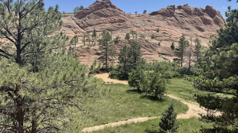
If you want the dramatic scenery of Colorado's distinctive red rocks without committing to a strenuous climb, the Red Rock Rim to Red Rock Canyon Trail offers a perfect introduction. Located in Red Rock Canyon Open Space on the west side of Colorado Springs, this roughly 2.4-mile loop combines broad views — you can see Pikes Peak from here — towering sandstone formations and remnants of the area's quarrying past. It's considered a good route for children and families, since it offers spectacular views with minimal elevation gain and is stroller-friendly, if you have an all-terrain model.
As you progress through the loop, the scenery changes from dirt roads and open plains to enormous red-rock formations. These rocks are part of the Fountain Formation, a geological melange of sandstone over granite and metamorphic gneiss, seen across Colorado's Front Range. You'll also encounter evidence of the area's industrial 19th-century history during your hike. Red Rock Canyon was once home to quarries supplying building materials to early white settlers in the area. Like the Paint Mines Interpretive Trail, this loop offers hints of ancient human activity as well, dating as far back as 7,000 B.C.
For beginners, the route's modest elevation gain is a major advantage. Red Rock Canyon Open Space is a multi-use trail system, so hikers may encounter mountain bikers or groups on horseback. Dogs are allowed on these hiking trails, but must be leashed outside of designated off-leash areas. Both experienced visitors and the city of Colorado Springs recommend checking the weather before you hit the road, and sticking strictly to designated trails, even when muddy. Travelers can damage the sensitive landscape if they stray from the paths.
Perkins Central Garden Trail
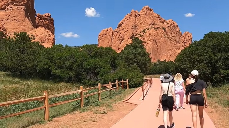
The Perkins Central Garden Trail, located in the Garden of the Gods Park in Colorado Springs, is a 1.1-mile paved, round-trip trail with very mild elevation. That makes it one of the park's easiest ways to get close to its enormous sandstone formations. This loop travels through the heart of the park, passing beneath some of its tallest and most recognizable attractions, including the so-called Kissing Camels. The enormous red and pink sandstone slabs are again part of the Fountain Formation, with dramatic rock spires and arches defining some of the key features that make Garden of the Gods a favorite spot for tourists and locals alike.
This park's history and backstory is as rich as the scenic views you'll pass through. The land was gifted to the city of Colorado Springs back in 1909, by the children of railroad tycoon Charles Elliott Perkins. This gift came with a set of non-negotiable stipulations, which are still strictly adhered to to this very day. The Perkins estate demanded that the park always be named Garden of the Gods, always remain free to the public, and that no new structures should be built on this land, except those necessary to maintain and protect the park. The estate also mandated that the park be a place "where no intoxicating liquors shall be manufactured, sold, or dispensed." The whole thing is overseen by a coalition of city government departments and private foundations.
Since the Garden of the Gods is such a crowd pleaser, you may find that parking is a challenge during peak hiking season. Still, the paved trail should make hiking the Perkins route very accessible. You're also only a couple of miles from the Red Rocks Open Space, meaning you could easily combine the two adventures.
Fountain Valley Trail
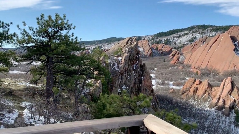
We've covered a myriad of state parks, but Roxborough State Park is one that truly shouldn't be missed. With just over 3,400 acres, the park offers a wide range of trails suited for beginning hikers, many of which link to much longer regional trails. One local favorite is the Fountain Valley Trail, which runs roughly 2.5 miles long, and includes an ascent of just under 400 feet. Like some of the other trails on this list, the FVT offers stunning views of jagged red rock formations, and access to tons of Colorado wildlife (dogs are not allowed anywhere in the park). Unlike most of the other entries, the park provides a tremendous view of Denver's historic downtown area, though not on this trail. Depending on your skill level, you can take a detour off of the Fountain Valley loop to check out Lyons Overlook, which offers a panoramic view of the entire park.
Beyond the stunning views, deer, foxes, black bears, and more wildlife can be spotted depending on the time of year, along with over 200 species of birds. There is a chance you'll bump into a rattlesnake, so staying on the trails is recommended. There are a few caveats worth keeping in mind: Though some sources say wheelchairs can navigate the loop, others find only the beginning section accessible. calling ahead to check conditions is recommended. Roxborough State Park is also known to have pretty spotty cell service, so make sure you've got a physical map and a compass on hand just in case.
Rainbow Gulch Trail
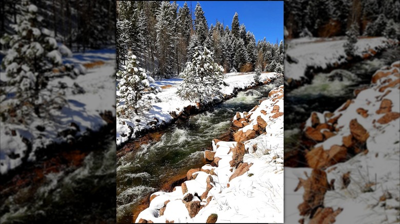
Closing out our list of beginner-friendly hikes in the Centennial State, we've got the Rainbow Gulch Trail, located in Pike National Forest. This easy out-and-back trail is 2.6-miles round trip, with just over 280 feet of elevation gain, and plenty of Colorado mountain scenery along the way. The route follows a gentle grade through pine and aspen forests, before reaching the reservoir's picturesque shoreline.
The forest setting makes this trail appealing throughout the warmer months of the year, with wildflowers in season and colorful aspen foliage in the fall. Keep an eye out for birds and other wildlife along the way, and listen for the rolling creek which gives the gulch its name. This path is also a scenic bike trail open to mountain bikers and horseback riders (ATVs and motorcycles are not allowed). Those traveling on foot should stay alert and be prepared to share the path.
The highlight of the Rainbow Gulch Trail is the Rampart Reservoir. This high-elevation lake is serene and surrounded by forest, with views of the neighboring mountains. Hikers can pause at the water before retracing their steps (you'll get great views of Pikes Peak), or continue along the longer Rampart Reservoir shoreline trail for a more ambitious outing. The full reservoir loop is nearly 15 miles, so beginners should be mindful not to mistake that extended route for the short Rainbow Gulch hike.