Explore Breathtaking Glaciers And Volcanic Peaks At Iceland's Largest National Park

In the United States, you can explore glaciers in areas such as Glacier National Park in Montana, Denali National Park in Alaska, and a handful of other locations in the northwestern portion of the country. You can also get a glimpse of active volcanoes in Hawaii's Volcanoes National Park. However, in Iceland it is possible to take in both of these stunning natural features, as well as a myriad of others, in a single location: Vatnajökull National Park.
Vatnajökull National Park is Iceland's largest national park. It is so big that it actually takes up 14% of the total surface area in the country. The national park and two adjoining protected areas cover an incredible 3.5 million acres. This makes it the second-largest national park in all of Europe. Although it is relatively recent as national parks go — having been established in 2008 — it has already be designated a UNESCO World Heritage Site.
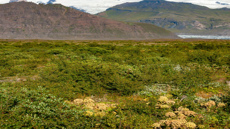
It is not just size alone which makes Vatnajökull National Park impressive. Rather, the litany of impressive natural features makes this park unique. It is home to both Iceland's tallest peak and its largest glacier. Europe's most powerful waterfall, based on volume, is also located within the park. Vatnajökull also features nearly a dozen volcanoes, a pair of which are some of the most active in the country. It also features a myriad of other geological features, including calderas, shield volcanoes, lava formations, craters, glacial plains, table mountains, deep canyons, and more. Additionally, there are a number of ice caves for exploring. All of this makes Vatnajökull National Park an adventurous destination to add to your bucket list.
Glaciers dominate the landscape
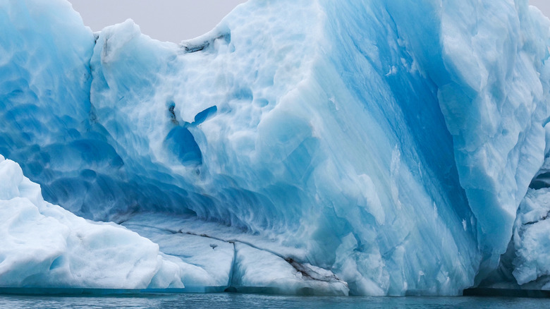
Glaciers — and geologic features formed by glaciers — are on full display within Vatnajökull National Park. The largest is the park's namesake glacier. Vatnajökull glacier has more volume than any other glacier in Europe. This single glacier blankets 8 percent of Iceland and averages 1,300 feet thick. At its thickest point, Vatnajökull is more than 3,200 feet deep. All told, the glacier covers more than 3,000 square miles.
Considered a retreating (melting) ice cap glacier, the southern end of Vatnajökull is second only to Mýrdalsjökull glacier in terms of amount of water draining into the ocean in Iceland. The southern portion of Vatnajökull National Park also features several outlet glaciers, as well as the two largest glacial lagoons in Iceland — Jökulsárlón and Fjallsárlón. Jökulsárlón is an Icelandic term meaning "glacial river lagoon," and is one of the country's top tourist attractions. However, these glacial lagoons were actually formed within the past hundred years due to climate change, as rising temperatures began to melt the glaciers along the Atlantic Ocean coastline. Today, visitors can view these glacial lagoons from Route 1 or book a boat tour.
The opposite side of the park is marked by geological features formed by glaciers and water. A myriad of canyons, ravines, and basins in the northern portion of Vatnajökull National Park have been formed by glacial movement through the centuries. The best known is Ásbyrgi, which is a gargantuan, horseshoe-shaped canyon. Also in the northern part of the park is the most powerful waterfall in all of Europe — Dettifoss waterfall. This incredibly strong waterfall sends more than 7,000 cubic feet of water fall over its 144-foot drop each second. One of the park's more popular hiking trails, located alongside Dettifoss, heads into Ásbyrgi.
Witness the effects of fire and ice at Vatnajökull
Vatnajökull National Park isn't just about glaciers. In fact, the geological features within the park perfectly encapsulate why Iceland is known as the Land of Fire and Ice. The country earned this moniker due to the juxtaposed dichotomy its icy glaciers and lava-spewing volcanoes. Even today, Vatnajökull National Park has plenty of both. In addition to Vatnajökull, multiple outflow glaciers, and a pair of glacial lagoons, the park also features close to a dozen central volcanoes. Among these are the largest and most active volcanoes in Iceland.
The majority of the volcanoes in Vatnajökull National Park are beneath the glacial ice cap. Even when buried beneath this thick layer of ice, however, they can erupt. When they do, molten lava meets glacial ice, resulting in a glacial outburst flood. The Icelandic term for such as event is jökulhlaups. Additionally, such volcanic outbursts can leave streaks of ash embedded in layers of ice, creating one of the park's more dramatic features. Iceland's largest active volcano, Öraefajökull, as well as one of its most active, Grímsvötn, are both beneath the Vatnajökull ice cap. Many of the mountains within the park, including Hvannadalshnúkur, which is Iceland's highest peak (6,952 feet), were formed as a result of volcanic activity.
Volcanic activity has also contributed to the landscape on the park's west side, dominated by craters and lava fields. On the east side of the park, Snæfell is one of the few central volcanoes located in Vatnajökull National Park that is not beneath the ice cap. It's actually the tallest mountain in Iceland that is not under glacial ice and is a popular spot to hike and view reindeer.