Visit Virginia's Largest Peak To Explore Wild Forests And Spot Unique Wildlife
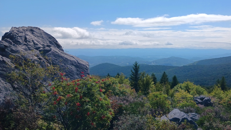
For hikers who crave more than a casual stroll through the woods, peak chasing or "peak bagging," adds an adventurous twist to the trail. This pursuit is all about tackling mountains with purpose, whether you're trying to climb the tallest summit in each state, rack up elevation milestones, or simply check iconic peaks off of a personal bucket list. And while you might think peak bagging means tackling the Rocky Mountains, where summits soar above 14,000 feet and wildlife roam the alpine slopes, don't overlook the smaller, more accessible peaks. Every state has a high point to explore, and in Virginia, that's Mount Rogers. Rising 5,729 feet above sea level, it offers summit seekers a chance to stand on the roof of the state and sample a slice of the Appalachian Trail. The views here are stunning any time of year, but outdoor enthusiasts love exploring this trail for its stunning fall foliage.
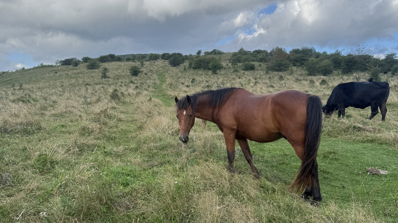
Mount Rogers is more than just a checkmark on a peak bagger's list, though. Located in the Mount Rogers National Recreation Area, this peak is surrounded by a wonderland of natural beauty. Picture dense spruce-fir forests that feel more like New England than the Southeast, wide-open mountain balds dotted with rocky outcrops, and trails that stretch across nearly 500 miles of rugged terrain. Wildlife here steals the spotlight too: Wild ponies graze across grassy ridges, birdwatchers can spot rare high-elevation species, and trout streams run cold and clear. Add to that opportunities for horseback riding, mountain biking, camping, and even cross-country skiing or snowshoeing in the winter, and Mount Rogers becomes a year-round playground for adventurers.
Camping at Mount Rogers' state parks
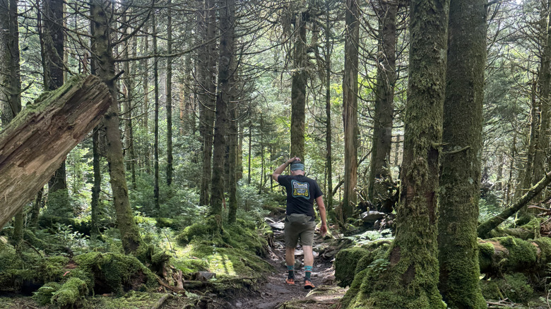
Named after William Barton Rogers, Virginia's first state geologist and the founder of the Massachusetts Institute of Technology (MIT), Mount Rogers is a playground for explorers. What makes this peak stand out isn't just its elevation but also its unusual ecosystems, which are rare in the southern Appalachians. This "sky island" of northern ecology offers hikers the chance to step into an environment unlike anywhere else in Virginia, a living relic of the Ice Age that persists here due to the cooler, wetter microclimate.
Camping around Mount Rogers adds another layer to the adventure, giving hikers the chance to immerse themselves in its history and unique terrain. You can engage in "dispersed camping" throughout the national forest as long as you follow Leave No Trace principles. The rule of thumb is to camp in an established, previously used site and avoid setting up your tent too close to trails or water sources. Camping along the Appalachian Trail — the longest hiking-only footpath in the world — means waking up to sweeping sunrises over ridgelines and possible encounters with the iconic wild ponies that roam the highlands. For those who prefer a more established setup, Grayson Highlands State Park offers campgrounds with facilities such as fire rings and restrooms. Meanwhile, primitive shelters along the Appalachian Trail provide a middle ground for thru-hikers.
Trail options for hiking to the Mount Rogers summit
Hiking to the top of Mount Rogers means choosing a trail that offers both challenge and reward, and two of the most popular routes take very different approaches to the summit. The Massie Gap route starting in Grayson Highlands State Park is the more scenic and popular path, especially if you like wider vistas and a mix of open ridgelines plus forest stretches. From Massie Gap, begin on the Rhododendron Trail for about 0.8 miles until you hit the Appalachian Trail, then continue past the Thomas Knob Shelter onto the Mount Rogers Spur Trail. The round-trip is approximately 8.9 miles with about 1,300 feet of elevation gain. Along this route, expect sweeping open balds and the chance to spot wild ponies grazing in the meadows before entering dense spruce firs as you approach the summit. While the pines obscure any view, you will find the U.S. Geological Survey marker on a large rock at the top.
If you're looking for a slightly quieter approach to Mount Rogers, take the Elk Garden route. From the Elk Garden trailhead (off Route 600), the Appalachian Trail leads roughly 4.5 miles one way to the summit via a mix of ridge hikes, forested climbs, and occasional exposed meadows. The round-trip distance is about 8.9 miles, with an elevation gain of around 1,770 feet, making it a moderate to strenuous hike. Early on, you'll cross open fields where cows and ponies roam before entering a shaded hardwood forest, then eventually reaching higher spruce-fir zones. About halfway through, the trail passes through the Lewis Fork Wilderness, where fallen logs and moss-draped branches lend a "magical forest" ambiance to the trail. This journey to the densely wooded summit provides quiet beauty and solitude undisturbed by heavy crowds.