There's No Shortage Of Sweeping Views While Hiking Vermont's Highest Peak
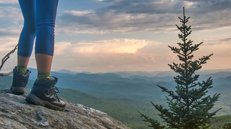
The Green Mountain State is home to a quaint combination of vintage towns, agriculture, and public land for the outdoor recreator. The state's tallest peak, Mount Mansfield, offers spectacular mountain views on your journey to the top, and the view from the summit is nothing short of magical. At the trail, natural beauty begins in the dappled light as you wander through northern hardwood forests. The scenic trail then rises through higher evergreen fir forests, until breaking through to rare alpine-tundra where 360-degree views of the state roll out beneath you. Once you're in the alpine section of the mountain, be sure to only walk on the rocks to protect this fragile ecosystem.
Trails in Underhill State Park start at around 2,000 feet and take you up to Mount Mansfield's summit of 4,395 feet. It's one of the most scenic hiking experiences in New England, regardless of the season. Fall can make for soggy boots, but the maple, beech, and birch trees blanketing the mountain's lower elevations are ablaze in autumn color from about mid-September to mid-October. A selection of hike-in campsites in the park makes for some great fall camping spots this time of year. For those seeking a blend of challenge, beauty, and solitude, heading up in winter provides a memorable experience — you might need snowshoes, skis, crampons, or poles depending on what route you take. Spring is known as mud season in the Northeast, though it can still be a stunning scene as the hardwood forests begin to show supple, bright green baby leaves while understory flowers break through the debris. Summer in Vermont is hard to beat, though, and it's easily the best time of year to head to Mount Mansfield. Blitz up this peak, rinse off in one of the area's swimming holes, and stop by a sugar shack for maple soft serve ice cream on your way through the nearby town of Stowe.
Trails to hike up Mount Mansfield
It's always a good idea to plan and prepare properly for any day hike like this one. Mount Mansfield is a noodle bowl of trails, and you need to spend a few minutes before setting out deciding which one you're going to attempt. The summit ridge runs north to south, and its ridgeline features resemble a person's profile on their back (nose, chin, forehead, Adam's apple). Vermont's iconic state-long thru-hike, called the Long Trail, traverses the summit ridge. If you start at the Lower Barnes Lot, you can hike the Long Trail to the Adam's apple and across the ridgeline, then descend via the Hazleton Trail for a hike that totals 7.8 miles.
Approaching through Underhill State Park, on the mountain's western side, is ideal because it's the more remote and undeveloped side. Several classic routes lead toward the summit ridge, including the Sunset Ridge Trail, a 3-mile approach that offers a steady climb and some of the best open ridgeline views in the state. Others take the Laura Cowles Trail, a steeper and shadier route that ascends through moss-covered forest and meets the ridge above the treeline. Looped together, these trails create a perfect 4.5-mile blend of demanding hiking and tranquil scenery.
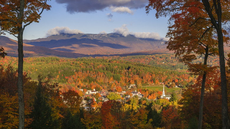
Whichever trail you take, the ultimate reward of hiking Mt. Mansfield via Underhill is the moment you break through the treeline, where the summit ridge opens into sweeping views. Lake Champlain lies to the west, the Green Mountains continue to the north and south, and on clear days, even the White Mountains of New Hampshire peek out over the horizon. Returning via the Sunset Ridge Trail offers regular vistas of the valley below, aglow with sunset colors if timed right. It's a nice distraction from your burning thighs and achy feet.